Day 31 - Breckenridge to Salida
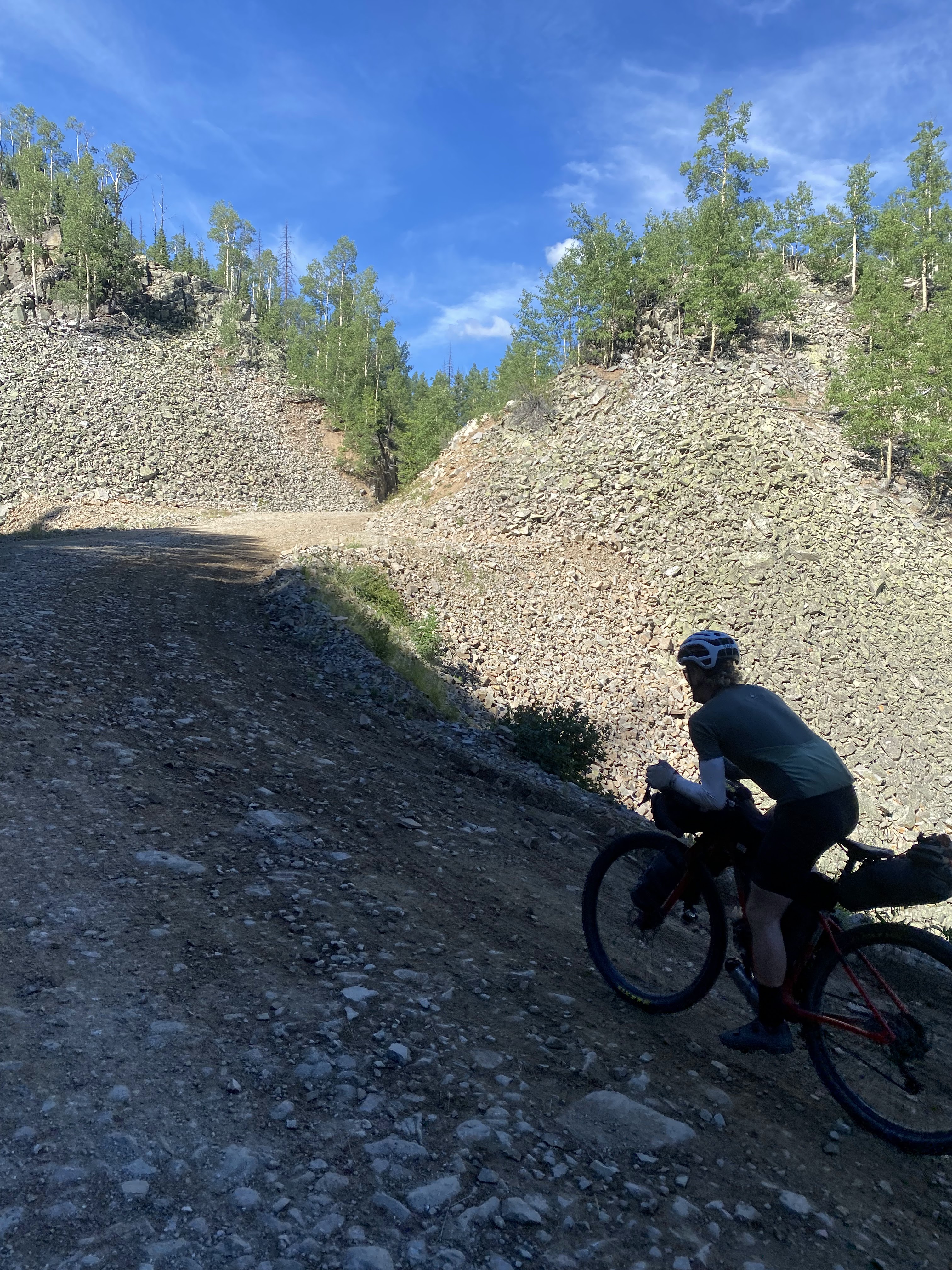
The AirBNB was near downtown Breckenridge, so our day started at the base of Boreas Pass Road, where we climbed around 2,000 feet to the pass, which was at 11,400 feet elevation. My brother rode up the climb with us on a mountain bike, and at the top, my parents met us in their car. We said goodbye and rode down the backside of Boreas Pass; the next people we'd see that we knew would be Will's dad and brother at the Mexican border (well, actually, we did see Taz again).
The descent off of Boreas Pass was somewhat chunky and incredibly scenic. It seemed to go on forever, and when we finally reached the bottom, we were met with open plains and miles of fast riding. We had a strong tailwind, and the mix of gravel and pavement saw us averaging over 20mph for quite some time.
About halfway through the day, we got to Hartsel, CO, where we stopped for some lunch. The restaurant was a pleasant surprise, and if I remember correctly, we each got a pretty big burger. I think I even paid a little extra for a buffalo burger.
After Hartsel, we had a little pavement, followed by some pretty nice gravel. An afternoon storm was looming, and before long, the sky was getting dark all around us. Lightning was flashing in the distance, and, wanting to avoid getting struck with lightning, we stopped for a snack and relaxed off the side of the road for maybe half an hour while the storm passed.
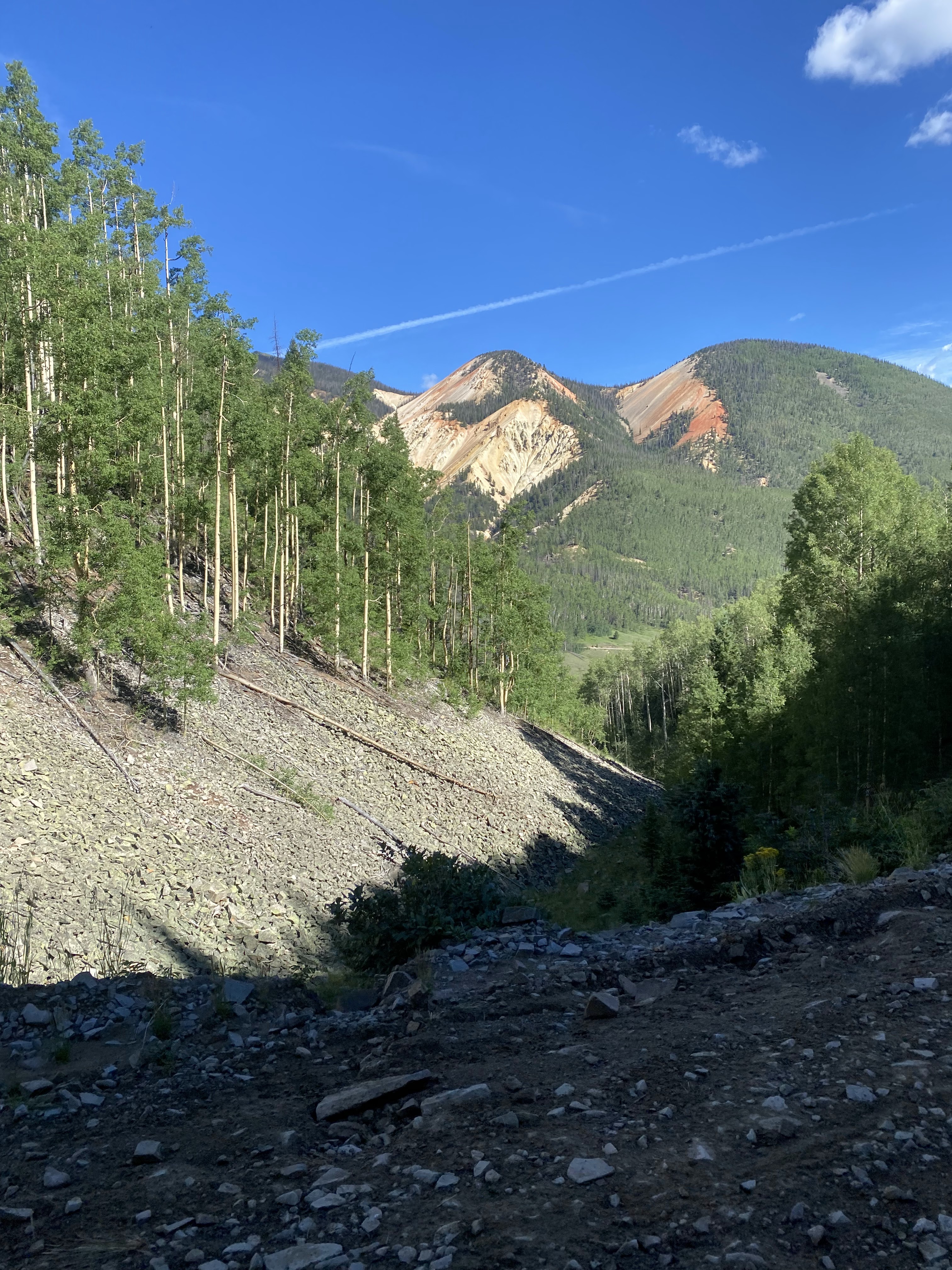
We got riding again and gradually made our way uphill. We were met with a great view of the valley overlooking Salida, and we knew we wanted to camp somewhere on the downhill. We checked the maps to see what was private land, and we slowly made our way downhill searching for a camps spot. We found a pretty good spot off the dirt road just a few miles before Salida, so we stopped there for the night.
There was a fox walking around the campground, which was especially funny for me, remembering how much Dicky loved a fox in Breckenridge last year.


Boreas Pass; flatland after Boreas Pass


Into the mountains near Salida


Mountain north of Salida; a red fox near camp
Day 32 - Salida to Luders Creek Campground
We started this morning with a huge gravel downhill into Salida, and the sunrise over the mountains was a pretty amazing sight. Once we reached the bottom of the mountain, we looked on the map to see where to stop for food. Nothing in Salida was on route, so we rode past Salida to a little suburb on the outskirts, where we stopped at a Walmart.
We stocked up on food, ate some donuts for breakfast, then got rolling on our way to Marshall Pass. The climb started on pavement, and after four miles or so on a highway, we turned off onto a gravel road to continue the climb. Marshall Pass was actually an old railroad, so it's not a steep climb at all. It was an extremely scenic and relaxing climb, with some awesome views and the perfect gradient to just soak in all the surroundings.
Near the top of Marshall Pass, we saw some bighorn sheep. Man, I'm a huge fan of those sheep. At the actual pass, we stopped for some pictures and some food. We knew there was going to be a little restaurant coming up soon, so we didn't wait around for too long.
The downhill off the pass was incredible. There's no other way to put it. The descent started fairly steep, at least steep enough to not really need to pedal. I wish I took some more pictures on the downhill, but I was having too much fun just cruising through the Rocky Mountains.
Soon enough (well actually, the downhill was a lot of miles long) we reached the tiny town of Sargents, Colorado. There was an all-in-one general store and restaurant there called Tomichi Creek Bar and Grill, so we stopped there for some lunch and for a little resupply.
The food was awesome, and the waiter kept the pitchers of Dr. Pepper coming. After the stop, there was a fairly long stretch of pavement, and then we turned off onto another gravel road. There was a sign on the road saying "No Playing in the Ditch", so I took a picture to send to Dahn Pahrs. I can't remember if I ever did send the picture or not.
The gravel road stretched for quite some time as we meandered up and down some rolling hills. The landscape was very open, and tree cover was limited. Eventually, we reached the last climb of the day, and rode up some switchbacks into the tree cover.
There were a lot of aspen trees in the forest, and I could tell we were going to have a great campsite. Sure enough, the primitive national forest campsite was a winner and was sitting at just over 10,000 feet. At the campsite, there were a couple other bikepackers, and we briefly talked to them about whatever bikepackers talk about.


Climbing Marshall Pass


Bighorn sheep on Marshall Pass


Nearing the top of Marshall Pass; the top of Marshall Pass


Another view of the top of Marshall Pass; some desert-like terrain past Sargents


Storm in the distance; back into aspens near Luders Creek Campground
Day 33 - Luders Creek Campground to Indiana Pass (highest elevation of route)
As we were walking toward the back of the campground to fill up our water at a spring, another bikepacking called down to us from his campsite.
"Make sure you don't drink any water near Indiana Pass, it's an EPA Super Site", he warned us.
Apparently, some sort of mine contaminated the water near Indiana Pass, which we'd be riding later in the day, so the water contained some bad chemicals. I've never read that before, but the guy seemed totally convinced.
We went about our business filling up our water, then set off for the day.
After a big downhill, our first climb was Carnero Pass. Will must've been feeling pretty good because he kicked it into gear and hammered up the whole climb. We both ended up beating the previous Strava KOM (not that I care at all), but of course Will beat me by almost a minute. Needless to say, it was a pretty painful climb.
The downhill off of Carnero Pass was extremely scenic, and we actually saw two other bikepacker dudes halfway down. We briefly stopped to chat, and then headed on our way.
A lightning storm was approaching, and before long, it seemed that the storm was directly above us. Lightning flashed around us, and the thunder, being so close by that it seemed to happen simultaneously with the lightning, echoed off the canyon walls around us.
A heavy rain set in, and we were soaked immediately. We were both a little bit worried about the lightning, but seeing as a restaurant as only a few miles ahead, we kept riding. The gravel turned to pavement for a couple miles, and we pulled in to the restaurant just as the rain was stopping
I felt bad coming in to the restaurant soaking wet, but no one seemed to care. We both ordered some food along with sweet tea, which came with free unlimited refills.
Just after leaving the restaurant, we met up with the other two bikepackers we had seen earlier on the descent. We ended up talking for a while, and it turns out the one guy was a track and field coach at a college in Iowa. Since Will used to run for Penn State, it was a pretty cool coincidence to run into a guy like that.
We also got to talking about biking in general, and the guy mentioned his friend Brian was doing Marji Gesick in the fall on a rigid singlespeed. Turns out that Brian ended up smoking me at Marji Gesick. I find it really fascinating to look back on instances like this.
We pointed them in the direction of the restaurant, and we headed off to Del Norte, the next town. The riding was very flat for the next few miles, but eventually, the roads turned into doubletrack. I think its safe to say the few miles outside of Del Norte were some of my favorite on the whole trip. It was pretty much perfect riding for me - a narrow, rocky road that weaved through a high-desert environment.
Once in Del Norte, we got some food at a Subway and resupplied at a gas station. We headed out of town on pavement and began our way up Indiana Pass, a massive 4,000+ foot climb.
The climb eventually turned to gravel and got a bit steeper, but we kept a steady pace and made good time. We were originally planning to camp somewhere on the ascent, but we decided to push to the top and camp just past the summit. Being as this was the highest elevation pass on the route, the views got more and more alpine the further we went. By the top, we were above the tree line, and huge fields of grass were dotted only with the occasional tree and sheep.
Yes, sheep. There was a herd of sheep up there along with a couple sheep dogs, but they were far enough away that we didn't think they'd bother us over night. We set up camp in a grass opening maybe 1/2 mile past the summit, at about 11,500 feet, and cooked some dinner. Overnight, it seemed like the sheep dogs kept getting closer and closer to us, but nothing ever happened, so it could've just been our imagination.


The downhill heading toward Del Norte


Downhill toward Del Norte; desert doubletrack near Del Norte


More desert-like terrain near Del Norte


The top of Indiana Pass


Views from where we camped just off the back of Indiana Pass
Day 34 - Indiana Pass into New Mexico
It was a crisp morning when we woke up at over 11,000 feet, but the sky was blue and we knew the sun would warm us up quickly. The first miles of the day were filled with several punchy climbs and some of the most incredible views of the trip. I guess I've said that superlative a lot, but these really were some of the best. Actually, I think I've said that justification before also, but trust me, some of the scenery around Indiana Pass is the kind of stuff you'd see in a post card or travel magazine for the Rocky Mountains.
Before long, we saw the giant mine that must have caused the EPA Super Site, and sure enough, there was a lot of odd colored water around. We still had plenty of water, so we didn't need to risk it.
After miles of high alpine riding and open views, we started the descent down into Platoro, Colorado. It was one of the roughest descents on the whole trip, with loose gravel and sharp turns keeping us on our toes. On the way, we passed a couple small lakes and an oddly reddish colored mountain.
As we emerged from the forested mountainside and into the valley, the town of Platoro came into view. It wasn't really a town, more of a collection of outfitter buildings and side by sides. There was a store there, so we got some breakfast and resupply.
Unfortunately, this was actually one of the few stores I would not recommend on the route. The people were friendly enough, I guess, but you could tell they took advantage of bikepackers and tourists in general. First, the food was outrageously expensive, like $9 for a tiny breakfast sandwich. Plus, the packaged food, like Lance crackers or Clif bars, was overpriced like I've never seen before.
To make matters worse, when I asked the clerk and owner about the town of Abiquiu, which we planned to be arriving at the next evening, she made it seem like a tiny town with no supplies in order to sell us more overpriced stuff. I think her exact words were, "Abiquiu makes us seem like a thriving metropolis".
Spoiler alert: Abiquiu was a modern town with gas stations, a main highway, and even a fancy resort.
We left Platoro feeling unsatisfied, and followed the river on a gravel road down the valley. We filled up water, which was quite dirty, from a campground well along the way, and then stopped at the Horca Gift Shop at the end of the gravel road.
Despite being a tiny gift shop, this little place was worlds better than Platoro, and only 15 miles or so down the road. We bought some sodas, some ice cream, a couple mini pies, and some general snacks. The owner was an extremely friendly older gentleman, and his wife also helped run the store. It was also a museum of sorts, and a couple other folks were getting a little tour of the place from the wife.
At the Horca Gift Shop was a blind woman who was racing the entire Tour Divide route, and she had a crew with her helping her out. There were a couple riders who would ride in front and behind her, playing Taylor Swift music so she could tell where to go, and calling out hazards along the way. Pretty incredible. We talked to the one guy who was helping out for quite a while.
We left the Horca Gift Shop feeling very satisfied, and started up La Manga Pass, a paved road climb around 2,000 feet gain that took us close to the New Mexico border. The climb and the miles following it went fast.
Eventually, we reached the blind cyclist's support van again a few miles ahead, and turned off the pavement onto a cool dirt road. There were a few short, punchy climbs, and then, we reached the New Mexico border. It was pretty surreal reaching New Mexico, seeing as it was our last state on the trip. Looking back, it's pretty hard to imagine what all we saw on the trip.
Once in New Mexico, the dirt road turned into rougher doubletrack, and before long, we were hiking up a rocky hill. This went on for a while, and the road occasionally had a fallen tree across it. After a few miles, we reached a national forest campground. It was completely empty, but afforded us a great view of the New Mexican mountains. It threatened to rain a couple times, but it never really did.


Just past Indiana Pass


Heading downhill toward Platoro
Great roads and views near Platoro


Heading into New Mexico; some hike-a-bike


Awesome roads near camp
Day 35 - Northern New Mexico to Abiquiu
This day had some of the best quality of riding of the trip. For the early part of the day, we stayed on narrow forest roads lined with pine trees. At one point, however, we ducked out of the forest and into the open, where we had to find a place to refill our water. The only option was a small, shallow creek in full-sun. The water was green with algae and warm, and cows spotted the landscape above us along the creek. Not exactly the ideal drinking water, but with a filter and iodine, we trusted it enough.
Turns out, we both giardia later on, but it's tough to say where we got it from.
After the water fill up and a quick snack, we meandered along dirt roads for a few miles before a long pavement climb. Once again, Will thought he was in a race, so he blasted full speed up the climb. I opted for a more reasonable pace.
At the top of the climb we stopped for lunch at the Hopewell Lake campground, before heading into more dirt roads in denser forest. A storm was appearing in the sky, and we were both hoping it wasn't going to make the roads too muddy.
We had heard conflicting opinions about the mud: some people warned us even the slightest rain would make the roads impossible, while others assured us that the usual afternoon storm was not enough to ruin the roads.
In our experience, in northern New Mexico (and I stress northern because the clay mud in the south is much different), it was somewhat in between. The storm hit us just after Hopewell Lake and the roads got muddy, but they weren't impossible. It wasn't the "death mud" that we had feared, but it certainly made for slower going. However, the localized nature of the storms meant that within a few miles, we rode out of the storm and the roads got pretty good again.
On the one downhill, we got passed by some rednecks in a pickup truck hauling out wood as we were stopped to eat some food. They were moving very slow, so we tried to give them enough time to get far ahead of us. We failed to give them enough time, and we passed them further down on the descent. They didn't seem too friendly, so we were hoping they didn't pass us again later on.
The dirt road descent turned into pavement and we cruised along the valley for a few miles before starting the next climb. The start of the next climb was pavement, and it felt very "Mexican", if that makes any sense. I guess what I mean is, the buildings and houses made it seem like you weren't in America anymore, and I think it goes to show the diverse nature of our country. Even the roads had Spanish names, and there's just something inexplicably Mexican about the way the houses looked.
Personally, I really love that kind of atmosphere, and if I moved anywhere else, the southwest with it's Mexican influence would probably be the place.
The climb turned into dirt, and we cruised our way up. There was one final descent on dirt, which ended up being a fantastic downhill. At this point, we were in Carson National Forest, which is where a massive wildfire had burned just a month earlier. On this particular downhill, we were surrounded by burned areas. It was really a breathtaking view; everywhere you looked were scorched trees and destroyed vegetation. The wildfires had caused flash floods, from a lack of vegetation to stop the water, so the landscape was filled with mini-arroyos caused by heavy rains. Everything looked very grey, and it seemed as if the area was burned and then a river flowed over top of it. I guess in reality that's about what happened.
At the bottom of the descent was a tiny town, if you could call it that, with a little Mexican restaurant. The place was called El Farolito, and the town was El Rito. We only had about $15 cash between the two of us, and the restaurant only accepted cash, so we were unsure how much food we could get.
As it turns out, the prices were extremely reasonable, and we each got a burrito and several sodas, all for $15 total. There were two employees, and waiter/server, and the cook, who seemed to own the place. They were both extremely friendly.
There were also several bikepackers stopped there, and we chatted with them for a few minutes. The one guy left his bike in the sun too long, and the sun's heat made his tire explode. They were all riding the Great Divide, and they were doing it in sections together - doing a new stretch every year.
To paint a little bit of a picture, let me describe the inside of the restaurant. It was dimly lit with only a handful of tables; the whole place was maybe only 300 or 400 square feet. It seemed quite "authentic", and on the walls were some maps of the area. The owner/chef came over to talk to us, and we chatted for a while.
He was used to seeing Great Divide cyclists come through, so we talked about the route and he gave us some insights about the rest of New Mexico. He said New Mexico is a lot like West Virginia, in that it has a lot of rednecks, except these rednecks speak Spanish. He didn't say it in a derogatory way, instead, almost in an endearing way. I've actually heard the same redneck description from other people, and I'd have to agree. But truly, I mean the term redneck in a very positive way - the people we met in rural New Mexico were perhaps the friendliest on the entire route.
After the food, it was a mostly downhill pavement cruise to Abiquiu. We had a couple options: either start climbing Polvadera Mesa, a 4,000 foot climb, or stay in Abiquiu at a little hotel. We opted for the hotel, and were able to get a good dinner at the hotel, too. It was actually a pretty fancy hotel, although still reasonably priced, so it worked out well.


Burn areas heading toward El Rito


The pavement to Abiquiu
Day 36 - Abiquiu to Cuba
We started the day off with a gas station breakfast and then headed to Polvadera Mesa. Some say it's the hardest climb on the entire GDMBR route; at the very least, it's over 4,400 feet from bottom to top. It starts off as a regular dirt road, winding up the desert mountain (is that an oxymoron?) in the exposed sun. The first section of the climb was maybe 1,500 feet, or a little more, and Will decided once again to go very fast. There was then a little flat section, followed a short but super steep section. This was all on a pretty drive-able dirt road.
Eventually, the road got rougher and rougher, and before long, it was a rocky, washboard jeep trail carved out by monsoon rains. I'm sure jeeps drive it, but there's no way the average car could make it up this road anymore. It continued like this for quite a while, and once again Will was trying to go pretty hard. It was hard to find a rhythm on the climb because it was a strange pattern of flat sand section-steep rocky section-flat sand section, and repeat. The road then climbed into more of a forested zone and got less sandy, so the going got a little faster. The final stretch to the top was really neat, the road was barely visible on the mountainside and it kicked up even steeper as we neared the summit. There were also some aspen trees, another sign that we had climbed up out of the desert.
At the top, we had some food, and then got to enjoy the fact that the rest of the day was gradually downhill.
This was another day that highlighted the excellent roads in New Mexico, as most of the day was on perfect forest roads with no traffic and just the right amount of chunk. The rolling climbs were sometimes steep, which highlighted another part of New Mexico on the route: its difficulty. I think New Mexico is the most challenging state on the route, at least when you're riding with someone like Will. Instead of having huge, gradual climbs where you find a groove and keep grinding, New Mexico had lots of smaller, steeper climbs that hurt quite a bit with a 50+ pound loaded bike. Of course, it also had the big climbs, it's just that it added in the short and steep ones compared to other states.
At one point in the day, it started pouring down rain. Luckily, it was warm out, and the roads surprisingly did not get destroyed too much. We got passed by some dirt bikers and side-by-side riders; I wonder what they thought about us riding in the rain on these roads.
On one of the last sections of forest road for the day, we were afforded an excellent view of the views and the storms in the distance. It was always a game with the afternoon storms, trying to judge where they'd go and how bad they'd be. In the end we sort of learned there was no point in guessing - nature was going to do what it wanted to do.
At one point, an SUV pulled up alongside us with a few women in. They were with the Girl Scouts and were trying to plan a bike trip for the scouts, with overnight camping. They asked us about our route and what we were doing, and we gave them a few tips. I'm still not sure exactly what they're plan was, but they were super friendly, so hopefully they ended up doing something cool.
We then rode past some sort of bike festival or race in the national forest, with tons of people hanging out with gravel bikes. It was pretty cool, and it definitely seemed more like a party than a hardcore race. After them, we saw a bunch of side-by-sides and quads driving on the forest roads; I think this part of the national forest is a pretty heavily used area.
The forest road eventually popped out onto a pavement road, and we had a massive downhill toward Cuba. It was one of the most fun pavement descents I have ever done; we were easily cruising at 40mph and the road had just the perfect amount of curves. Yeth, I'm a fan of curves. On roads. Duh. What did you think I meant? There was car behind us on the descent, but we were going so fast that they didn't pass us.
The terrain got much more desert-like as we reached Cuba, and we got the feeling we might not be seeing the forested mountains much more on the way to the border. In Cuba, we got some McDonalds, then rode to a hotel. Normally, we wouldn't get two hotels in a row, but there were limited options for hotels in the coming miles, and there was no good place to camp near Cuba, so we figured it was worth it. Plus, it was an extremely cheap room, which made the decision even easier.
At the hotel, there were a couple people outside our room hanging out, and they talked to us for a while about their upcoming adult-league baseball game. They asked us about our trip, and seemed interested in what we had to say. I'd say they fell into the category of New Mexico redneck, and like I said earlier, those people were the friendliest people on the entire route. The term redneck to me is more of an affectionate descriptor.


Climbing Polvadera Mesa


Jeep roads after Polvadera Mesa

Some of my favorite "roads" on the whole trip
No comments:
Post a Comment