The Steelers were actually playing on Monday Night Football, so we put the game on the hotel TV and then commenced the route planning process. We basically had 5 more full days of riding, and on the last night we wanted to be back in Phoenix to start getting ready to fly home the following morning.
At first, we [well, technically, just me, but Will was there for moral support] tried plotting some random routes but after some thinking, we found the Gila River Ramble route on bikepacking.com, which was a 110 mile mountain bike loop starting near Superior, Arizona. We assumed it could take us 2.5 days to do the route if it was gnarly singletrack, so counting a day to ride to the route start from Phoenix and a day to ride back to Phoenix, it seemed like the perfect choice. I plotted a route from the hotel to the route start, and we went to bed.
Next morning: wake up, enjoy a huge continental breakfast (with foods from all the continents, as Will would say), and get rolling. We cruised through suburban Phoenix and Scottsdale, then made it to the Arizona Canal. Coincidentally, that was also the Maricopa Trail, which we had ridden on a few days before north of Phoenix.
The canal was pretty much entirely flat, but it was still pretty cool. We saw a couple bald eagles and then some wild horses. I don't think I've ever seen wild horses before, so that was pretty neat.


After getting off the Arizona Canal, we stopped at a bike supply vending machine in Apache Junction (I think) to get some extra mini bottles of tire sealant. Then, we found a surprise Chipotle right along the route, so of course we got lunch.
More mundane road miles, and then we reached US Route 60. This route was much busier and had a much narrower shoulder than expected. We tried to ride on some dirt paths along the side of the road, and we succeeded for a while, but eventually we gave in and just rode the narrow shoulder for a couple miles.
We turned off US 60 and headed northeast, and within a couple miles, we were on a really cool gravel route. There were cacti all around, and the road just cut straight through the desert. We eventually cruised through a little golf course community on some pavement, then made it the edge of the national forest.
The road we turned on (and the one we were supposed to take all the way to the Arizona trail) had a sign that said "Road Closed 5 Miles Ahead".
We asked an old man in a parking lot if the road was still passable by bike, and he replied, grumpily, "oh yeah, I just drove through there myself and so did that cop over there".
Perfect, I thought. Although for some reason, something didn't quite seem right. But whatever.
We started riding out the road and the closed signs kept warning us; "Road Closed 3 Miles Ahead". "Road Closed 2 Miles Ahead".
Finally we reached the closed section. There were no-trespassing signs everywhere, and there was a big gate with a chain.
However, off to the right was an old railroad bridge where there was a gap in the fence we could get through. We assumed it would be fine to just squeak through and walk across the bridge.
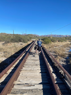 |
| The old train bridge |
We got out onto the bridge and it was pretty scary. The wooden railroad ties were old and rotting, and some of them were completely missing. So we were probably 80 feet off the ground walking our bikes across a narrow, rotted bridge with obviously no railing.
I don't really want to get into specifics for various reasons, but let's just say that we had to turn around on the bridge quite hastily and find another way to get to the Arizona trail.
Dang. That really got the blood flowing. In hindsight, we should've known not to do it, but the old man in the parking lot sounded pretty convincing that you could get through.
And now we had to figure out a detour to get to our camp spot for the night on the Arizona Trail.
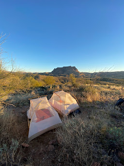 |
| Campsite the night after the railroad bridge incident |
The next morning, we rolled back down the AZ trail and into the town of Superior for breakfast. We stopped at a nice little diner, where I ordered a chicken-fried steak with gravy. Man, that was good.
There was also a group of people hiking the AZ trail in there for breakfast, and a girl just a little older than me asked us some questions about our bikes and routes. She knew about the Fool's Loop and also knew about bikepacking, which is a pretty niche thing. It was really neat to talk to someone who actually knew what we were doing.


After leaving the diner, we rode on a pavement road for a mile or two, then turned onto a rocky doubletrack road. I honestly think it might've been the rockiest stretch of the whole trip. There was literally a climb section on the road that was softball size loose rocks for maybe 1/2 mile. I somehow managed to ride up the climb, but it was a total struggle and it would've been better just to walk. Perhaps karma got me for trying to show up Mother Nature, because near the top of the doubletrack, on a different section with washboard shale sections, I tipped over and narrowly avoided a bad accident.
After we reached the top of the climb, the road was incredibly scenic, and it stretched through the mountains before dipping downhill into a much greener area where it met up with the Arizona Trail.


The first few miles on the Arizona trail were a combination of tall grass (similar to the beginning of the Black Canyon Trail and Maah Daah Hey trail), these really cool small red bushes, and burn zones where Saguaro cacti were scorched black from fires.
After a few miles of that, we entered a canyon. The pictures really cannot do it justice. It's definitely one o the most incredible trails I've ever ridden. In terms of remoteness, it felt really far into the backcountry, which added to the allure. The trail was steep at times, had high exposure at times, and was rocky at times.
Will got a flat on an uphill - he sliced his sidewall pretty bad. He was able to plug it with a Stan's dart, and we kept rolling. It was one of those stretches where you sort of don't talk at all for a while. Your brain is entirely focused on not falling down the massive canyon and checking out all the amazing scenery.


Eventually, we made it through the canyon and started a massive downhill. The downhill started out rocky and slow, but it soon became smoother and faster. By the time we reached the bottom of the 2000-ish foot downhill, the terrain had changed from canyons and mountains to lowland desert along the Gila River, extremely sandy and full of cacti.


We saw a javelina down there by the Gila River, and I also got stuck by a cactus. There was a Saguaro cactus fallen across the trail (just like a tree back home in Pennsylvania), so we both dismounted to walk our bikes over it. Just as I dismounted, I kicked my foot into a cactus and several sections of the cactus stuck into my ankle. I pulled them off, but my ankle was pretty irritated for quite some time.
Campsite on the Arizona trail

After riding on the Arizona trail for a few more hours, it got near time to find a campsite. We found a pretty cool place right off the trail on BLM land, so we set up our tents there.
The night before, we opted not to use our rain fly's both because it was warmer, and there was no room for them since we had to put our tents right next to each other on the limited flat ground. This night, we also decided to use no rain fly's. This was a mistake, because it got below freezing and frost fell on the tents/sleeping bags overnight.


The next day, we started with a mile of the AZ trail, then a 1200 foot gradual gravel climb. After the big climb, there was a gradual descent through the desert on a rough, sandy doubletrack section. We passed by some cows, some people camping in RV's, and tons of cacti.
At the bottom of that descent, the course got extremely sandy for a couple miles. It was basically like riding on a beach. I read some people's comments that this section was un-rideable, but since we were doing the route in reverse (for logistics reasons), we were going slightly downhill in the sand and it was rideable.
After the sand, we made it to the town of Florence, where we got some food and supplies. I ate way too much - two double quarter pounders, among other things - and struggled for the next few miles, haha. We had to cross a creek on the route again after lunch; it wasn't very deep or fast moving, but the creek bed was very soft mud, so our feet sank into the ground and were quite muddy when we walked out on the other side.
After the creek crossing, we began a long gradual climb on dirt roads that eventually lead to one of the most amazing sections of road/doubletrack I've ever ridden. It was called Box Canyon (pictured above), and its basically riding up through a narrow canyon for several miles. It was a mild climb, but after popping out of the canyon, things got real again, and the route got steep and loose
We were actually ahead of pace at this time, so we decided to push up and over the summit of the big climb and camp somewhere on the Arizona trail. The rest of the climb was pretty brutal, and I could understand why they recommend to ride the route the other direction. For most of the route, it was perfect doing it the direction we did, but this one section was too steep to ride up.
We pushed our bikes for a while, and then finally reached the top of the climb. The downhill off the summit to the Arizona trail was incredible. It was a winding doubletrack down a mountainside, and the barren desert landscape gave way to a slightly more green, alpine look.
We then met up with the Arizona trail again and began heading north on it. After maybe a mile or two of riding, we found a crazy camp spot on a mountain pass. Now, I understand we aren't talking about 12,000 foot Colorado mountain passes, but in the true definition of a mountain pass, that is what we camped on.


As you can see, it was a pretty sweet spot. There were plenty of cacti nearby, plus an adequate flat spot for the tents. As the sun began to set, the orange on the mountains was incredibly picturesque. We were able to find some firewood, and we set up a little fire ring,


Surprisingly, starting a fire here isn't as easy as just having a single spark ignite a pile of wood. Granted, it's way easier than a fire in Pennsylvania, but it still takes a little thought. But, we still got a fire going pretty easily, and we found enough wood to keep a small fire going for a couple hours.
At night, the sky was mostly clear with just a couple clouds. It was another extremely scenic view. Also at night, we ate our staple dinner: tortillas with single serve pouches of tuna on them.
Pro-tip: if you heat the tortilla on the rocks next to the fire, it both heats it up and crisps it a little bit. It was actually a pretty satisfying dinner. When we ran out of tuna, we took the remaining tortillas and ripped them into strips, which we then set on the rocks for a few minutes. If you did it right, they turned into tortilla chips.
The next day, we rode the remaining 10 or so miles on the Arizona trail before backtracking on some doubletrack heading west toward Phoenix. We did some doubletrack following a power line for a few miles before stopping at a restaurant for lunch. After that, we headed toward the Superstition Mountains.
We started in on a singletrack trail, but it was incredibly rocky. Too rocky to be fun. So we turned around and took some roads to get to Highway 89, which is the Apache Trail. Once on the main road, we checked a map to find a way to get into the Tonto National Forest.
We found a little dirt road that led into the national forest, so we took that road and planned to just make some random turns to find someplace cool to camp. We passed a couple dudes in an old pickup truck slowly moving along the dirt road, and kept going deeper into the wilderness.
Eventually, we made a turn onto another jeep trail, took that for about a mile, then turned onto a horse trail that went directly into the Goldfield Mountains.
The horse trail was unrideable, so we had to hike-a-bike up the hill for a while. As we neared the top, we spotted a big cliff with some rocks near the base of it. We both thought it would be an insane camp spot, but we knew it was unlikely there'd be a suitable tent spot. So, I put my bike down and hiked over the rocks to see if it was good. Surprisingly, there was a spot for the tents.
So, we pushed our bikes a little more and got to the spot to set up. It was amazing; we put our tents right at the base of a big cliff, and there was a rock blocking the view of the valley, which meant we were completely secluded in our little camp spot.


We set up the tents and then went for a little hike up to the top of the cliff. It was an amazing view of the Superstition Mountains and the surrounding area. We just sat there on the rocks for maybe half an hour and talked about random things.


After getting some pictures, we explored a little more of the horse trail that was nearby. The trail itself was a light grey color among the darker brown rock it went over, a sign that many horses and people over the years had worn away the lichen that covered the rock.


Our little camp spot reminded me a lot of a place a group of bandits might hide out, or where Indians might have camped hundreds of years ago. It was definitely a fantastic final night of camping.


As it got dark, we got a fire going on the flat part of a big rock. It was perfect, because we had a good sitting spot on the rock and there was enough wood nearby to have a little fire for several hours.
Since it was the last night camping, we did a little reflecting on the trip and just enjoyed sitting around the fire in the mountains of Arizona.
The following morning, we packed up and headed to Phoenix. On the way to Phoenix, we hit a lot of singletrack in the Usery Mountain Park. The trails were fantastic, and it was a great way to have some fun on the last full day of the trip. We did some trails that are probably too rocky for a drop bar bike, but we had lots of fun anyways. It was pretty much exactly what I think of when I think of Arizona singletrack.
After the trails, we took the Arizona canal back into Phoenix and got to our hotel. The hotel was nice to have the final night because we could figure out logistics and get ready to fly home to Pittsburgh the next day. The hotel wasn't great, but it was good enough.
The next morning, we got some breakfast at a place nearby then rode to my friend Joe's house. We packed up our bikes, caught an Uber XL to the airport, and made the journey back home to Pittsburgh.
Looking back at it, the trip was some of the most fun riding and camping I've ever done. There is something so special about being out in the wilderness with only your bike. I'm very glad that Will wanted to head out to Arizona for 10 days with me, it was a great experience and definitely an awesome way to spend New Years and my winter break from school.
It also made me think about the year ahead, we'll see, but something I'm really considering is the triple crown... riding the Tour Divide, Arizona Trail 800, and Colorado Trail all in the same year. We'll see. Either way, I hope to do a lot more exploring, racing, and riding in the coming year.
No comments:
Post a Comment